Poplar Island Environmental Restoration Project
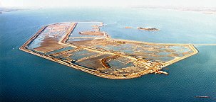
 The Poplar Island Environmental Restoration Project (PIERP) is being constructed through the use of sediment dredged from the shipping channels for the Port of Baltimore. The dredged sediments are being placed on the historic site of Poplar Island, which had eroded to a few acres over the past 150 years. The project will restore the Island to its approximate 1847 size and footprint. More information on the overall project is available at the web sites maintained by the Port of Baltimore: http://www.mpa.maryland.gov/greenport/Documents/Poplar_Fnl_Oct2015.pdf
and the US Army Corps of Engineers, Baltimore District: http://www.nab.usace.army.mil/Missions/Environmental/PoplarIsland.aspx
Part of the effort associated with the restoration of Poplar Island is to monitor the adjacent habitats to assess effects that may result from the construction and operation of the project. Monitoring studies include exterior sediment, benthic community, benthic tissue, water quality, natural oyster bar, nekton utilization, submerged aquatic vegetation (SAV), and wetland vegetation monitoring.
The following reports present the results of Maryland Geological Survey projects that monitored the sedimentation effects on adjacent natural oyster bars. Summaries of these reports are presented on this page. The entire reports can be downloaded in PDF format from the links below each report summary. The PDF file are large and may take a long time to download.
| |
File Report 02-01: Evaluation of Sedimentation Impacts
on Natural Oyster Bar 8-10 from Dike Construction at the Poplar Island Environmental
Restoration
Project |
| |
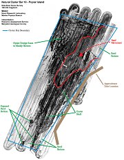
 SUMMARY: The sedimentation study performed by MGS on Natural Oyster Bar (NOB) 8-10 was designed to test the hypothesis that there would be no increase in sedimentation on the bar during construction of the containment dike around PIERP. The study was part of an effort designed to ensure minimal impact from the construction of PIERP to the surrounding area. NOB 8-10 lies to the west of the dike adjacent to the northwest section of the perimeter dike at PIERP. Water depths within NOB 8-10 range from less than 12 feet adjacent to the dike, to over 18 feet in the northwest portion of the bar. The original experimental design consisted of comparing pre- and post-construction sedimentation patterns at three sites within NOB 8-10 to three reference sites located outside of the hydrodynamic influence of PIERP; however, higher than expected sediment mobility around NOB 8-10 led to a change in the study design. For the revised study, it was decided that sediment deposition would be measured on a larger scale within NOB 8-10 before and after construction to determine impacts to the oyster bar from PIERP dike construction. Sedimentation caused by PIERP dike construction would be expected to appear as a thicker layer of sand closest to the dike that became thinner toward the western edge. Bathymetry readings before and after dike construction depicted generally similar patterns of sediment accumulation on NOB 8-10. Side scan sonar records after dike construction did suggest that a thin layer of sand, a few centimeters thick, covered small areas in NOB 8-10 close to the dike. This thin layer of sand was thick enough to cover objects interpreted as oyster shell from pre-construction side scan sonar readings. The proximity to the dike suggests that the thin layer of sand may be attributable to dike construction at PIERP. A follow up side scan sonar survey conducted in August 2000, showed similar bottom conditions at NOB 8-10 as those from the previous surveys. There was no evidence of additional sand accumulating over the oyster bar or that the sand that was over the oyster shells in the previous surveys had been removed due to the proximity of PIERP. SUMMARY: The sedimentation study performed by MGS on Natural Oyster Bar (NOB) 8-10 was designed to test the hypothesis that there would be no increase in sedimentation on the bar during construction of the containment dike around PIERP. The study was part of an effort designed to ensure minimal impact from the construction of PIERP to the surrounding area. NOB 8-10 lies to the west of the dike adjacent to the northwest section of the perimeter dike at PIERP. Water depths within NOB 8-10 range from less than 12 feet adjacent to the dike, to over 18 feet in the northwest portion of the bar. The original experimental design consisted of comparing pre- and post-construction sedimentation patterns at three sites within NOB 8-10 to three reference sites located outside of the hydrodynamic influence of PIERP; however, higher than expected sediment mobility around NOB 8-10 led to a change in the study design. For the revised study, it was decided that sediment deposition would be measured on a larger scale within NOB 8-10 before and after construction to determine impacts to the oyster bar from PIERP dike construction. Sedimentation caused by PIERP dike construction would be expected to appear as a thicker layer of sand closest to the dike that became thinner toward the western edge. Bathymetry readings before and after dike construction depicted generally similar patterns of sediment accumulation on NOB 8-10. Side scan sonar records after dike construction did suggest that a thin layer of sand, a few centimeters thick, covered small areas in NOB 8-10 close to the dike. This thin layer of sand was thick enough to cover objects interpreted as oyster shell from pre-construction side scan sonar readings. The proximity to the dike suggests that the thin layer of sand may be attributable to dike construction at PIERP. A follow up side scan sonar survey conducted in August 2000, showed similar bottom conditions at NOB 8-10 as those from the previous surveys. There was no evidence of additional sand accumulating over the oyster bar or that the sand that was over the oyster shells in the previous surveys had been removed due to the proximity of PIERP.
Click here to download this
report in Adobe Acrobat PDF format  (88.3
mb, large file) (88.3
mb, large file) |
| |
File Report 02-05: Evaluation of Sedimentation
on Natural Oyster Bar 8-11 from Dike Construction at the Poplar Island Environmental
Restoration Project: |
| |
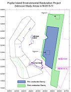
 SUMMARY: The surveys conducted as part of this study indicated that there was little oyster shell identified within the boundaries of NOB 8-11 to the east or southeast of Coaches Island. While small groupings of shell, and isolated individual shells may have been present in the area, there were no large groupings identified. A comparison of the pre- and post-construction side-scan sonar records in the vicinity of the dike construction area provided no indication that additional sediment moved into the boundary of NOB 8-11 as a result of construction activities. Proximal to the dike the bottom appeared to be largely smooth and flat sands both prior to and following construction. There was no evidence that dike construction activities had produced any movement of sand into the boundaries of the oyster bar. SUMMARY: The surveys conducted as part of this study indicated that there was little oyster shell identified within the boundaries of NOB 8-11 to the east or southeast of Coaches Island. While small groupings of shell, and isolated individual shells may have been present in the area, there were no large groupings identified. A comparison of the pre- and post-construction side-scan sonar records in the vicinity of the dike construction area provided no indication that additional sediment moved into the boundary of NOB 8-11 as a result of construction activities. Proximal to the dike the bottom appeared to be largely smooth and flat sands both prior to and following construction. There was no evidence that dike construction activities had produced any movement of sand into the boundaries of the oyster bar.
Click here to download this report in
Adobe Acrobat PDF format  (1.6
mb) (1.6
mb) |
|
| |
|
 The Poplar Island Environmental Restoration Project (PIERP) is being constructed through the use of sediment dredged from the shipping channels for the Port of Baltimore. The dredged sediments are being placed on the historic site of Poplar Island, which had eroded to a few acres over the past 150 years. The project will restore the Island to its approximate 1847 size and footprint. More information on the overall project is available at the web sites maintained by the Port of Baltimore: http://www.mpa.maryland.gov/greenport/Documents/Poplar_Fnl_Oct2015.pdf


 SUMMARY: The sedimentation study performed by MGS on Natural Oyster Bar (NOB) 8-10 was designed to test the hypothesis that there would be no increase in sedimentation on the bar during construction of the containment dike around PIERP. The study was part of an effort designed to ensure minimal impact from the construction of PIERP to the surrounding area. NOB 8-10 lies to the west of the dike adjacent to the northwest section of the perimeter dike at PIERP. Water depths within NOB 8-10 range from less than 12 feet adjacent to the dike, to over 18 feet in the northwest portion of the bar. The original experimental design consisted of comparing pre- and post-construction sedimentation patterns at three sites within NOB 8-10 to three reference sites located outside of the hydrodynamic influence of PIERP; however, higher than expected sediment mobility around NOB 8-10 led to a change in the study design. For the revised study, it was decided that sediment deposition would be measured on a larger scale within NOB 8-10 before and after construction to determine impacts to the oyster bar from PIERP dike construction. Sedimentation caused by PIERP dike construction would be expected to appear as a thicker layer of sand closest to the dike that became thinner toward the western edge. Bathymetry readings before and after dike construction depicted generally similar patterns of sediment accumulation on NOB 8-10. Side scan sonar records after dike construction did suggest that a thin layer of sand, a few centimeters thick, covered small areas in NOB 8-10 close to the dike. This thin layer of sand was thick enough to cover objects interpreted as oyster shell from pre-construction side scan sonar readings. The proximity to the dike suggests that the thin layer of sand may be attributable to dike construction at PIERP. A follow up side scan sonar survey conducted in August 2000, showed similar bottom conditions at NOB 8-10 as those from the previous surveys. There was no evidence of additional sand accumulating over the oyster bar or that the sand that was over the oyster shells in the previous surveys had been removed due to the proximity of PIERP.
 SUMMARY: The surveys conducted as part of this study indicated that there was little oyster shell identified within the boundaries of NOB 8-11 to the east or southeast of Coaches Island. While small groupings of shell, and isolated individual shells may have been present in the area, there were no large groupings identified. A comparison of the pre- and post-construction side-scan sonar records in the vicinity of the dike construction area provided no indication that additional sediment moved into the boundary of NOB 8-11 as a result of construction activities. Proximal to the dike the bottom appeared to be largely smooth and flat sands both prior to and following construction. There was no evidence that dike construction activities had produced any movement of sand into the boundaries of the oyster bar.